Coregistration
Note
In this chapter, we use ref and sec abbreviations when refering to the reference input DEM (input_ref) and the secondary input DEM (ìnput_sec) respectively.
Introduction
A possible coregistration configuration would be the following:
"coregistration": {
    "method_name": "nuth_kaab_internal"
}
Be aware that demcompare’s coregistration is performed in three steps:
i) Reprojection
Because radiometric differences are used to estimate the planimetric and altimetric offsets between both DEMs, demcompare needs both DEMs to rely on the same geographic grid. This means that operations such as crop and resampling are first performed to ensure both DEMs can actually be compared pixelwise:
the crop is done based on the DEMs a priori intersection
the resampling ensures both DEMs share the same resolution. The default resolution is the one of the
input_secDEM.
The output of this step are two DEMs intuitively called reproj_REF.tif and reproj_SEC.tif.
ii) Offsets estimation
This is the actual coregistration part. Demcompare will use one implementation of [NuthKaab] algorithm to estimate the x, y, and z shifts between reprojected DEMs (namely reproj_REF and reproj_SEC).
The output of this step are two DEMs intuitively called reproj_coreg_REF.tif and reproj_coreg_SEC.tif.
iii) Shift of the input_sec DEM from x and y planimetric offsets
The last step consists in changing the origin of the input_sec DEM so that it now matches the input_ref ones.
The output of this step is then a coreg_SEC.tif DEM. One can now open the input_ref and the coreg_SEC.tif in a GIS viewer and, hopefully, observe no residual shift.
Schematic overview
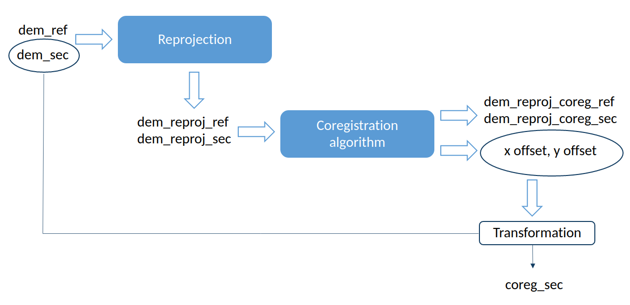
Fig. 1 Demcompare’s coregistration schema
Note
Please notice that both reproj_coreg_ref and reproj_coreg_sec share the same georeference origin, but this origin may not be the same as the origin of reference DEM. Hence, they shall only be used for computing altitude difference for statistical purposes.
Note
Notice that if a single DEM is given as input, the coregistration step cannot be computed obviously.
Warning
Be careful that the coregistration altimetric z shift is given as output information but is not used for dem coregistration in demcompare. The altimetric shift can be from many sources and its correction could blur the comparison analysis.
Detailed parameters
Sampling source
By default, both reprojected DEMs will have sec’s resolution. However, one may consider ref’s resolution specifying the coregistration’s sampling_source parameter on the input coregistration configuration.
A possible coregistration configuration with reference’s resolution would be the following:
"coregistration": {
    "method_name": "nuth_kaab_internal",
    "sampling_source": "ref"
}
Initial shift
The user may have a prior estimation of the shift between the input DEMs. In this case, the parameters estimated_initial_shift_x and estimated_initial_shift_y may be specified. If the estimated initial shifts are given, demcompare will apply them to the input_sec DEM before the coregistration algorithm.
A possible coregistration configuration would be the following:
"coregistration": {
    "method_name": "nuth_kaab_internal",
    "estimated_initial_shift_x": 2.5,
    "estimated_initial_shift_y": -0.6
}
Number of iterations
The number of iterations in the Nuth & Kaab algorithm can be modified, by specifying the number_of_iterations parameter. By default this value is set to 6 iterations.
A possible coregistration configuration would be the following:
"coregistration": {
    "method_name": "nuth_kaab_internal",
    "number_of_iterations": 10,
}
Coregistration analysis
The coregistration may be analyzed by computing the altitude difference with and without the coregistration along with its histogram.
To do so, the user needs to have two configuration files: one with coregistration and one without coregistration.
The two configuration files should specify the statistics step including an alti-diff step in the input configuration.
The two configuration files should look like:
"coregistration": {
    "method_name": "nuth_kaab_internal"
},
"statistics": {
    "alti-diff": {
    }
}
and
"statistics": {
    "alti-diff": {
    }
}
Several other metrics, other than the altitude difference can be used, as described in Statistics.
If the statistics step with an alti-diff step is specified in the input configuration file, demcompare will compute the altitude differences.
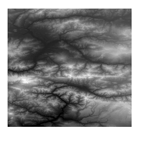
Fig. 2 Superposition of two DSMs that need to be coregistered.
In this example, the two uncoregistered DEMs had the initial altitude difference shown on the following image.
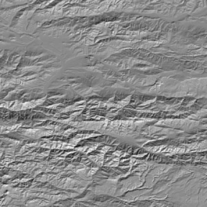
Fig. 3 Initial altitude difference between the two DSMs.
After Nuth et Kaab coregistration, the final altitude difference between both coregistered DEMs is shown on the following image:

Fig. 4 Final altitude difference between the two coregistered DSMs.
The altitude differences are computed with the reprojected DEMs with and without the coregistration.
Full list of parameters
Scientific parameters
Here is the list of the parameters of the input configuration file for the coregistration step and its associated default value when it exists:
Name |
Description |
Type |
Default value |
Required |
|---|---|---|---|---|
|
Planimetric coregistration method |
string |
|
No |
|
Number of iterations
of the coregistration method
|
int |
|
No |
|
Estimated initial x
coregistration shift
|
int |
|
No |
|
Estimated initial y
coregistration shift
|
int |
|
No |
|
Sampling source for reprojection |
string |
|
No |
|
If save internal DEMs and coregistration
method outputs such as iteration plots
to disk (true/false value)
|
boolean |
|
No |
I/O parameters
The different DEMs used and created during the coregistration step along with plots to analyze the coregistration algorithm and performance will be saved to disk according to the input configuration.
Output files and their required parameters
The coregistration images and files saved to disk :
Name |
Description |
|---|---|
|
Output json file containing coregistration offsets |
|
Logging file |
The images and statistics are saved in the stats/alti-diff (since alti-diff is specified in the configuration) directory if both coregistration and statistics options activated on the configuration :
Name |
Description |
|---|---|
dem_for_stats.tif |
Altitude differences image when both DEMs have been reprojected to the same grid. |
dem_for_stats_snapshot.png |
Snapshot plot of the altitude difference. |
dem_for_stats_pdf.png |
Plot of the probability density function of the altitude difference. |
dem_for_stats_pdf.csv |
Data of the probability density function of the altitude difference. |
dem_for_stats_cdf.png |
Plot of the cumulative density function of the altitude difference. |
dem_for_stats_cdf.csv |
Data of the cumulative density function of the altitude difference. |
The coregistration images saved with the coregistration save_optional_outputs option set to true:
Name |
Description |
|---|---|
reproj_coreg_SEC.tif |
Reprojected and coregistered secondary DEM. |
reproj_coreg_REF.tif |
Intermediate coregistered reference DEM. |
reproj_SEC.tif |
Intermediate reprojected secondary DEM. |
reproj_REF.tif |
Intermediate reprojected reference DEM. |
coreg_SEC.tif |
Coregistered secondary DEM |
nuth_kaab_iter#.png |
Iteration fit plot |
ElevationDiff_AfterCoreg.png |
Elevation difference plot after coregistration |
ElevationDiff_BeforeCoreg.png |
Elevation difference plot before coregistration |
Note
Both reprojected DEMs will have the secondary’s georeference grid.
Note
Both coregistered DEMs will have the secondary’s georeference grid and an intermediate georeference origin.
Manual application of the coregistration offsets
If desired, the obtained x and y offsets may be manually applied using the following GDAL command with the obtained GDAL offset bounds:
gdal_translate -a_ullr <ulx> <uly> <lrx> <lry> /PATH_TO/secondary_dem.tif /PATH_TO/coreg_secondary_dem.tif
Being <ulx> <uly> <lrx> <lry> the coordinate bounds of the offsets applied on sec. They are shown on logging the information after coregistration or stored in the coregistration_results.json file as gdal_translate_bounds.
Output directories
With the command line execution, the following directories that may store the respective files will be automatically generated. The data that the directories can contain is also indicated.
.output_dir
+-- sample_config.json
+-- stats
    +-- alti-diff
        +-- dem_for_stats.tif
        +-- dem_for_stats_snapshot.png
        +-- dem_for_stats_cdf.csv
        +-- dem_for_stats_cdf.png
        +-- dem_for_stats_pdf.csv
        +-- dem_for_stats_pdf.png
        <classification_layer_name*>
            +-- stats for each mode
+-- coregistration
    +-- coregistration_results.json
    +-- coreg_SEC.tif
    +-- reproj_REF.tif
    +-- reproj_DEM.tif
    +-- reproj_coreg_SEC.tif
    +-- reproj_coreg_REF.tif
    +-- nuth_kaab_tmp_dir
        +-- nuth_kaab_iter#*.png
        +-- ElevationDiff_AfterCoreg.png
        +-- ElevationDiff_BeforeCoreg.png
Note
Please notice that some data will be missing or some directories will be empty if the required parameters are not activated.
References
For the Nuth & Kääb universal coregistration algorithm :
Nuth, C. Kääb, 2011. A. Co-registration and bias corrections of satellite elevation data sets for quantifying glacier thickness change. Cryosphere 5, 271290.